Google's AI Predicts Deadly Flash Floods by Analyzing News Reports
By admin | Mar 12, 2026 | 2 min read
Flash floods rank among the world's most lethal weather phenomena, claiming over 5,000 lives annually. They are also notoriously challenging to forecast. Google believes it has found an unconventional solution to this problem: analyzing news reports.
While extensive weather data exists, flash floods are too brief and localized to be monitored as comprehensively as temperature or river flow. This data gap prevents advanced deep learning models, which are increasingly used for weather prediction, from accurately forecasting flash floods.
To address this, Google researchers employed Gemini, the company's large language model, to analyze 5 million global news articles. This process identified reports of 2.6 million distinct floods, which were then converted into a geo-tagged timeline called "Groundsource." According to Gila Loike, a product manager at Google Research, this marks the first time the company has used language models for such a purpose. The research and data set were made public on Thursday morning.
Using Groundsource as a real-world foundation, the team trained a model based on a Long Short-Term Memory (LSTM) neural network. This model processes global weather forecasts to generate the probability of flash floods in specific locations.
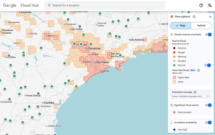
Google's flash flood forecasting model now identifies risks for urban areas across 150 countries on its Flood Hub platform and shares this data with emergency response agencies worldwide. António José Beleza, an emergency response official with the Southern African Development Community who tested the model, stated it enabled his organization to react to floods more swiftly.
The model does have limitations. Its resolution is relatively low, assessing risk across 20-square-kilometer zones. It is also less precise than the U.S. National Weather Service's flood alert system, partly because it does not incorporate local radar data for real-time precipitation tracking.
However, a key objective of the project was to function in regions where governments cannot invest in costly weather-sensing infrastructure or lack extensive meteorological records. "By aggregating millions of reports, the Groundsource data set helps rebalance the map," explained Juliet Rothenberg, a program manager on Google's Resilience team. "It allows us to extrapolate to other regions where information is scarce."
Rothenberg added that the team hopes this method of using LLMs to create quantitative data sets from qualitative written sources can be applied to other fleeting but critical phenomena, such as heat waves and mudslides.
Marshall Moutenot, CEO of Upstream Tech—a company using similar deep learning models to forecast river flows for clients like hydropower firms—said Google's work is part of a broader push to assemble data for deep learning-based weather models. Moutenot, who co-founded dynamical.org, a group curating machine learning-ready weather data, noted, "Data scarcity is one of the most difficult challenges in geophysics. There's simultaneously too much Earth data, and yet not enough ground truth for evaluation. This was a really creative approach to obtain that data."
RELATED ARTICLES
Comments
Please log in to leave a comment.
No comments yet. Be the first to comment!